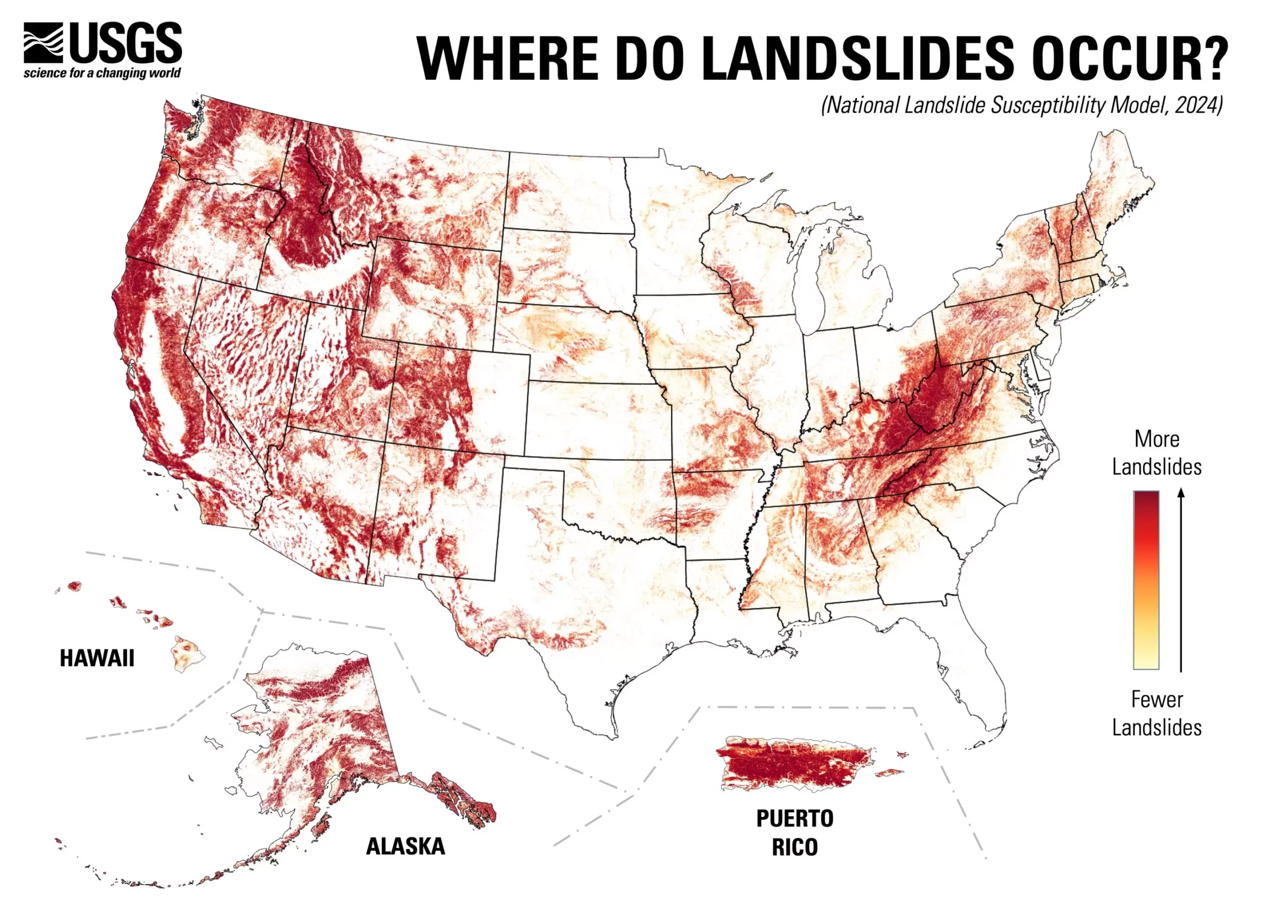
The U.S. Geological Survey (USGS) has recently unveiled a groundbreaking landslide susceptibility map, revealing that a staggering 44% of the United States is at risk for potentially devastating landslide activity. This new resource not only highlights the areas most vulnerable to such geological events but also emphasizes regions where the risk is minimal. By presenting a more intricate, county-by-county overview, the map is poised to be a crucial tool for risk management and urban planning efforts across the nation.
Historically, detailed assessments of landslide risks had been confined to specific regions, often dictated by the likelihood of occurrence. The new nationwide mapping approach signifies a paradigm shift in understanding and mitigating landslide hazards. Leveraging an impressive database of nearly one million previous landslide incidents combined with high-resolution elevation data from the USGS 3D Elevation Program, this assessment employs advanced computational methods to generate a comprehensive model. As Ben Mirus, a USGS research geologist, articulated, this effort answers a pivotal query: identifying susceptible areas across the breadth of the U.S.
By revealing previously understudied regions, the map provides invaluable insight for planners, engineers, and communities at large. Understanding where landslide hazards loom allows for proactive measures, including zoning regulations and infrastructure planning that take into account the inherent risks. This preparedness could significantly reduce the potential for property damage, loss of life, and economic disruption caused by landslides, emphasizing the crucial role of informed decision-making in risk management.
The public availability of this map marks an essential step towards fostering a hazard-ready nation. It empowers individuals to be informed about the geological risks in their vicinity and encourages collaborative community planning efforts. By integrating public awareness with scientific research, communities can build resilience against potential landslide threats, underscoring the importance of education in the face of natural hazards.
The map’s release invites further exploration of areas where land stability remains uncertain, encouraging additional mapping and research into landslide susceptibility. As communities utilize this information, they can significantly improve their mitigation strategies. The USGS’s commitment to continuous improvement in landslide assessment will cultivate a culture of vigilance and anticipation, ultimately leading to better outcomes in safeguarding lives and properties against such geological threats.
The USGS’s nationwide landslide susceptibility map serves as a valuable resource for understanding and mitigating geological risks. By providing detailed insights into landslide-prone areas, it empowers communities and planners alike to take informed steps toward reduction of hazards. The significant data and research behind this initiative showcase not only an advancement in geological sciences but also a commitment to fostering a more resilient future for all Americans.


Leave a Reply