Nitrogen dioxide (NO₂) is a colorless gas that presents a significant challenge to air quality and public health. This pollutant, primarily generated from anthropogenic activities such as the burning of fossil fuels in cars and power plants, is not just an environmental concern but also a health peril. It contributes to the formation of ground-level ozone and smog, both of which are detrimental to respiratory health. Given the increasing urbanization and industrial activity worldwide, it has become imperative to monitor and manage nitrogen dioxide emissions effectively. Recent advancements in satellite technology present a promising avenue for improving air quality assessments.
Traditionally, monitoring nitrogen dioxide levels relied heavily on ground-based measurements or broader satellite observations that lacked spatial precision. However, breakthroughs utilizing the Copernicus Sentinel-2 and Landsat satellites have changed the dynamics of air quality monitoring. These satellites, primarily designed for terrestrial observations, have demonstrated an unexpected ability to detect and measure NO₂ plumes with unprecedented precision. This capability heralds a new era of air pollution monitoring that can provide finer details about emission sources, particularly urban power plants that historically contributed significantly to air pollution.
The Copernicus Sentinel-2 satellites were initially tailored to study land use, vegetation health, and water quality. Yet, their high-resolution imaging capabilities make them ideal for now observing atmospheric conditions. This study serves as a pivotal moment, showcasing how current satellite technology can be repurposed to fulfill roles previously relegated to specialized instruments. By exploiting the visible and near-infrared wavelengths, these satellites can capture snapshots of nitrogen dioxide emissions that were previously elusive, thus enriching our understanding of how emissions vary across different times and spaces.
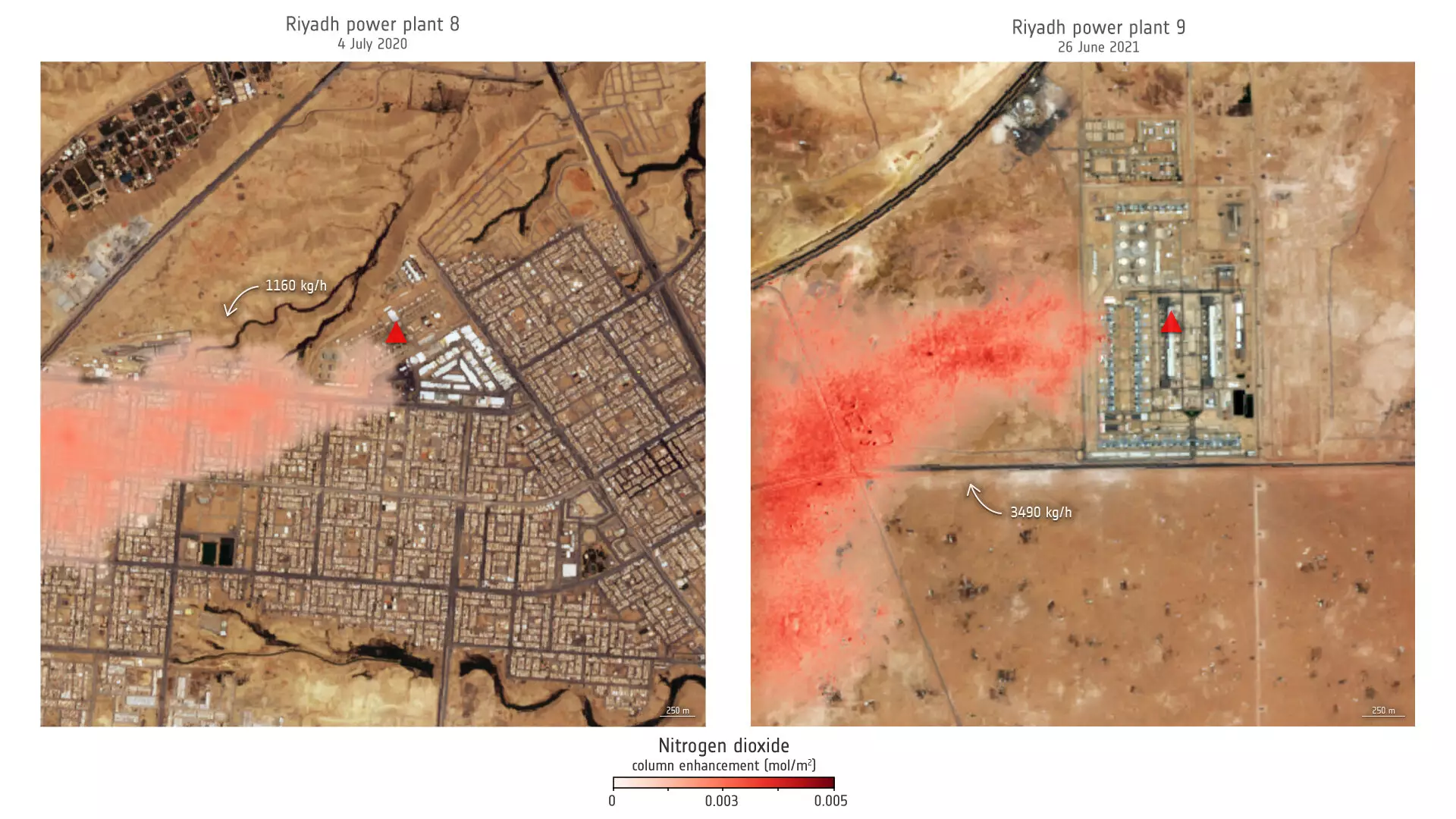
Focusing on significant power plants in Saudi Arabia and the United States, researchers have unveiled fascinating emissions data through detailed satellite imagery. This study analyzed power plant emissions over various seasons, revealing notable trends. For instance, the research highlighted a particular Saudi power plant that recorded higher emissions during the peak summer months, coinciding with increased energy use for air conditioning. Understanding these seasonal fluctuations allows policymakers and researchers to decipher emission behavior and implement targeted interventions.
Lead researcher Daniel Varon’s insights underscore the importance of this research. He noted that the adaptability of sentinel satellites to detect nitrogen dioxide emissions can be crucial in densely populated urban environments where pollution monitoring has traditionally been complicated by numerous, closely clustered sources. This advancement offers a practical tool for immediate application in urban air quality management, transforming how officials and residents can respond to pollution spikes efficiently.
Challenges in Satellite Monitoring
Despite the remarkable advancements, relying on satellite technology does come with complications. For instance, the performance of these satellites may be hampered by complex topographical features or non-uniform surfaces such as water bodies or densely built environments. Yet, even with these limitations, the benefits of harnessing satellite technology are vast. The ability to monitor air pollution on a grand scale through high-resolution images offers researchers and environmental regulators a powerful method to analyze and understand pollutants like NO₂.
This innovative approach could bridge the gap in monitoring systems, especially in regions lacking the infrastructural capabilities for traditional air quality assessments. The implications of this data are far-reaching, with the potential to enhance predictive models and inform public health guidelines.
As the Copernicus Sentinel-2 program continues to evolve with upcoming missions like Sentinel-2C, our capabilities in environmental monitoring will only expand. With advanced imaging technologies providing real-time, detailed analyses of atmospheric conditions, the power to track and manage nitrogen dioxide emissions will undoubtedly enhance strategies for mitigating pollution.
The implications extend beyond merely understanding pollution levels; this technology fosters the establishment of proactive policies aimed at fostering better air quality standards and improving public health. Policymakers can leverage precise satellite data to create more effective regulations and encourage sustainable practices among industries and communities alike.
With each step forward in satellite capability, we inch closer to a future where air pollution can be effectively monitored and managed, bringing us closer to the goal of cleaner air and healthier populations. The synergy between technology and environmental advocacy has never been more critical, and by leveraging such innovations, we may finally find a way to safeguard air quality for future generations.
Leave a Reply