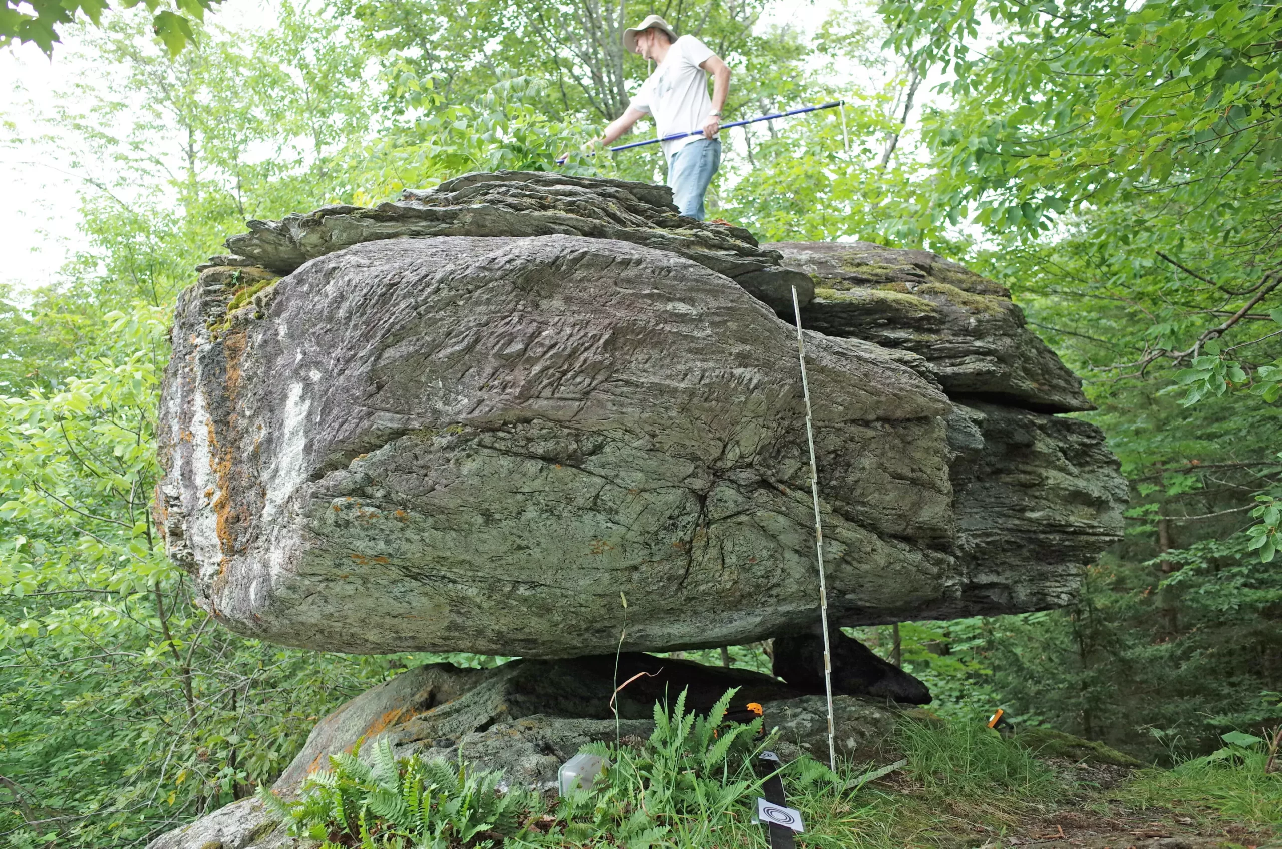
Recent studies in northern New York and Vermont have uncovered intriguing insights about the region’s seismic activity through the examination of five precariously balanced rocks (PBRs). These glacial erratics serve as geological markers that help scientists define the maximum anticipated shaking intensity from potential earthquakes. By evaluating how fragile these PBRs are, researchers can infer the levels of ground shaking necessary to potentially displace them. This approach offers a novel way to estimate seismic hazards across an area with a significant history of tectonic activity.
PBRs, formed by glaciers and resting on rocky pedestals, provide a unique window into the seismic history of their environments. As researchers like Devin McPhillips and Thomas Pratt from the U.S. Geological Survey demonstrated, the age of these formations—dating back approximately 15,000 to 13,000 years—provides critical information about past seismic events. Their existence implies that specific levels of earthquake shaking have not occurred in those regions since the glaciers retreated.
The study of these rocks is particularly relevant given their position in a seismically active area. Findings indicate that the overall data associated with the PBRs aligns closely with the U.S. Geological Survey’s 2023 National Seismic Hazard Model. This correlation strengthens the understanding of potential seismic risks within the northern Adirondack Mountains and surrounding Lake Champlain valley areas. Notably, one outlier PBR at Blue Ridge Road suggested a possible lower seismic risk in its vicinity, hinting at complex geological realities that underpin earthquake hazard assessments.
One intriguing aspect of the research involves the creation of new maps designed to illustrate the minimum distances required for significant earthquake sources to avoid toppling specific PBRs. Such maps serve not only as tools for seismologists but also as important resources for assessing where active faults may lie in relation to these geological features. Establishing a clearer picture of fault locations can greatly contribute to understanding earthquake risks and preparedness strategies.
Previous methodologies employed in more seismically active regions, like New Zealand and parts of the western United States, often lacked focus on the eastern U.S., where seismic threats are perceived differently. This current study brings a fresh perspective to the field, suggesting that while earthquakes might not be as prevalent as in other parts of the world, the risks are nonetheless significant and require rigorous research to define them accurately.
Despite the promising findings, researchers faced unique challenges in studying PBRs in northeastern regions. The heavily forested and rugged terrain hindered the identification of these fragile structures. The successful discovery of the five rocks was greatly aided by local enthusiasts and resources, indicating the importance of community involvement in scientific research. Guides from hiking enthusiasts proved invaluable in pinpointing these geological landmarks, demonstrating how local knowledge can significantly enhance scientific endeavors.
The team utilized advanced technology such as ground-based lidar and conducted thorough field observations to analyze the physical characteristics of the PBRs. By understanding the relationship between the boulders and their pedestals, McPhillips and Pratt were able to calculate the likelihood of a boulder being dislodged under varying conditions of ground acceleration. Their meticulous approach presents a model that may better characterize seismic hazards not only in their immediate study area but across similar geological contexts.
The research conducted illuminates the valuable role that PBRs can play in enhancing our understanding of earthquake risks in the eastern United States. McPhillips expressed optimism about the potential for discovering more PBRs, which could refine seismic hazard calculations and elevate awareness of the region’s geological dynamics. Given the historical context of significant seismic events—such as the 1944 Massena earthquake and others—investigating PBRs represents a critical step in grasping the seismic landscape.
In a broader context, as the field of seismology evolves, it is essential to apply diverse methodologies to gain comprehensive insights into earthquake risk assessments. Whether through studying precariously balanced rocks or employing other geological markers, the commitment to understanding seismic hazards is vital not just for researchers but for communities at risk. The ongoing investigations, the lessons learned, and the innovative approaches taken in this study promise to shape future research, enhance preparedness, and ultimately protect northern New York and Vermont’s residents from the challenges posed by seismic activities.


Leave a Reply