The quest for high-precision positioning in urban environments has long been hindered by a multitude of factors including signal obstructions, multipath effects, and interference from tall structures. Traditional Global Navigation Satellite System (GNSS) implementations, particularly Real-Time Kinematic (RTK) systems, have struggled to deliver the accuracy and reliability required in these complex settings. The dense urban fabric, comprising high-rise buildings and diverse materials, results in incomplete or distorted satellite signals, thereby minimizing the effectiveness of conventional GNSS methods. These challenges underscore the need for innovative solutions that enhance positioning accuracy in situations where traditional systems falter.
Past interventions to mitigate these challenges included leveraging alternative technologies such as Wi-Fi and Bluetooth, yet they often fell short in meeting the necessary performance metrics. This is where the advent of 5G comes into play. With its promising attributes of high-speed data transmission, extensive bandwidth, and increased deployment density, 5G technology appears to offer a new frontier for urban positioning. The ability to support diverse applications while enhancing satellite communication presents a noteworthy opportunity to revitalize RTK systems in urban landscapes characterized by signal interference.
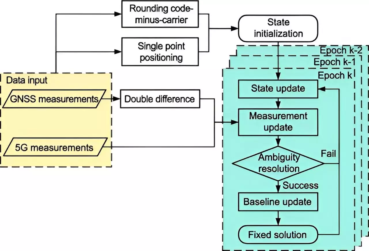
A pioneering study conducted by researchers at Tsinghua University has resulted in the creation of a 5G-assisted BeiDou Navigation Satellite System RTK positioning framework. The research, published in the scholarly journal Satellite Navigation, highlights the integration of an extended Kalman filter alongside sophisticated ambiguity resolution methods, fundamentally merging 5G data with traditional satellite observations. This innovative approach aims not just to bolster existing positioning frameworks but to significantly uplift their performance amid the signal challenges posed by urban infrastructures.
The critical evaluation of this new system revealed drastic improvements in positioning precision. Utilizing gain factors to assess both float solutions and Ambiguity Dilution of Precision (ADOP), the researchers observed a staggering 48% reduction in spatial errors in full ambiguity resolution mode, alongside an 18.8% improvement in partial ambiguity resolution mode. Moreover, fixing rates in both modes soared, indicating the robustness of the approach. These enhancements demonstrate that 5G technology acts as a powerful ally in the battle against signal disruption, enhancing the overall efficacy of positioning systems.
Dr. Tengfei Wang from Tsinghua University articulated the transformative potential of merging 5G with BDS RTK systems, asserting that this integration significantly enhances signal quality and satellite visibility. The implications stretch beyond mere positioning accuracy—ranging from autonomous vehicles and public safety to broader smart city frameworks. As 5G networks gain traction globally, the newly developed RTK system stands as a scalable and versatile tool poised to revolutionize location-based services in urban settings. Ongoing research endeavors aim to test this system across diverse real-world scenarios, setting the stage for continual enhancement in urban navigation excellence.
The alliance of 5G technology with traditional positioning systems such as BeiDou presents an exciting prospect for the future of urban navigation, paving the way for smarter, more reliable, and accurate location services in increasingly complex environments.


Leave a Reply