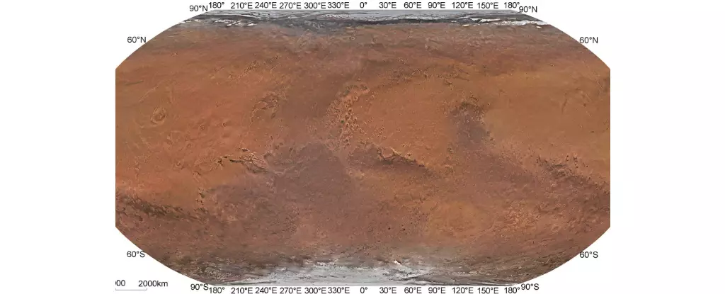
In July 2020, China’s Tianwen-1 mission successfully arrived in orbit around Mars, marking a significant milestone in interplanetary exploration. This mission, led by the China National Space Administration (CNSA), is comprised of six key elements designed to investigate Mars’s geology, internal structure, atmosphere, and the presence of water on the red planet. Tianwen-1 aims to gather valuable data that could potentially provide insights into the possibility of past or present life on Mars. As part of the mission, a team of researchers from the Chinese Academy of Sciences (CAS) utilized sophisticated technology to create the first high-resolution global color-image map of Mars, offering unprecedented detail and accuracy.
Over the years, several global maps of Mars have been generated using data collected by various spacecraft and instruments. For example, maps created by missions such as Mariner 9, Viking 1 and 2, Mars Global Surveyor, Mars Reconnaissance Orbiter, Mars Express, and Mars Odyssey provided valuable information about the Martian surface. However, these maps often had spatial resolutions that fell short of the level of detail required for comprehensive analysis. The global color images of Mars were particularly limited in resolution, with few maps offering spatial resolutions of a hundred meters or higher.
The team of researchers from CAS, led by Professor Li Chunlai and Professor Zhang Rongqiao, made significant advancements in mapping technology by utilizing data acquired by the Tianwen-1 orbiter. By processing the image data and optimizing orbit measurements using bundle adjustment technology, the team was able to create a seamless, high-resolution global mosaic of Mars. The use of Mars Mineralogical Spectrometer data and color correction techniques enabled the team to produce a true-color map with unparalleled accuracy and detail. The resulting Tianwen-1 Mars Global Color Orthomosaic 76 m v1 map offers a spatial resolution of 76 meters and horizontal accuracy of 68 meters, making it the highest-resolution true-color global map of Mars to date.
The creation of this groundbreaking map opens up new possibilities for future exploration and research on Mars. The high level of detail and color authenticity provided by the Tianwen-1 map will serve as a valuable reference for space agencies and partner organizations looking to study and map the Martian surface. The map’s enhanced resolution could aid in the selection of landing sites for future robotic missions seeking to uncover more about Mars’ history and potential for life. Additionally, as NASA and China plan for crewed missions to Mars in the coming decades, the Tianwen-1 map could play a crucial role in guiding these ambitious ventures.
The development of the high-resolution global color-image map of Mars by the Tianwen-1 mission represents a significant achievement in planetary exploration. The meticulous work conducted by the research team from CAS has produced a map that not only surpasses previous maps in terms of resolution and accuracy but also sets a new standard for future Mars mapping endeavors. As humanity’s interest in Mars continues to grow, maps like the Tianwen-1 Mars Global Color Orthomosaic 76 m v1 will undoubtedly play a vital role in expanding our knowledge of the red planet and paving the way for future exploratory missions.


Leave a Reply