In the critical and often perilous world of firefighting, time is as vital as the water used to combat the flames. Firefighters often face harrowing situations where they must evacuate quickly to avoid being engulfed by wildfires. Traditionally, the evaluation of escape routes has relied heavily on instinct and years of on-ground experience. However, recent advancements in technology give hope for a safer future through the newly developed modeling tool, STRIDE (Simulating Travel Rates in Diverse Environments). This article delves into the importance of STRIDE, how it was developed, and its potential impact on firefighting and other fields that require mobility assessment across varied terrains.
Firefighting is fraught with unpredictability and danger. When battling a wildfire, the ability to quickly determine the safest and most efficient escape route can mean the difference between life and death. Current tools primarily focus on slope steepness to predict travel times, neglecting significant factors such as vegetation density and ground surface conditions. This lack of detailed data often misrepresents travel time, leading to critical underestimations. The inadequacy of traditional models became glaringly evident in tragic incidents like the Yarnell Hill fire of 2013, further underscoring the necessity for improved predictive models.
Mickey Campbell, a research assistant professor at the University of Utah and lead author of the study introducing STRIDE, emphasized that understanding mobility is essential for firefighter safety. By developing a comprehensive model that incorporates factors beyond mere slope, STRIDE aims to enhance the efficiency and safety with which firefighters assess their escape routes during emergencies.
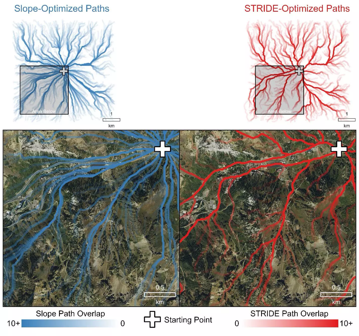
The STRIDE model introduces a transformative approach by integrating multiple factors affecting travel time. Researchers utilized advanced airborne Light Detection and Ranging (LiDAR) data, which allows for precise mapping of landscape structures, revealing nuances such as vegetation density and ground roughness. The methodology behind STRIDE involved analyzing aerial data alongside field tests to create an intuitive, yet exceptionally accurate model. This model not only identifies paths a firefighter would logically select—roads and trails—but also accurately predicts travel times, outperforming traditional slope-only models.
LiDAR technology operates by sending millions of laser pulses to bounce off objects in the environment, creating a highly detailed three-dimensional representation of the landscape. The STRIDE model harnesses this technology to provide a clear understanding of travel dynamics across diverse environments, whether urban areas or rugged wilderness. As the study reported, STRIDE consistently produces reliable estimations of travel times, making it a breakthrough in the quest for firefighter safety.
The efficacy of the STRIDE model was validated through a series of field trials conducted in varied terrains, which included urban environments, forests, and steep mountain landscapes. Volunteer participants navigated predetermined paths while researchers collected data on their travel times. By correlating STRIDE’s predictions with real-world performance across diverse settings, they succeeded in showcasing the model’s robustness.
Significantly, the trials emphasized the importance of incorporating multiple travel impediments rather than relying solely on slope measurements. STRIDE adeptly predicted travel rates that closely aligned with the actual paths chosen by participants, validating its theoretical superiority and practical utility over conventional models. This rigorous testing structure ensures that STRIDE not only offers theoretical predictions but is also grounded in practical application.
While the initial focus of STRIDE is to enhance firefighting responses, its applications extend far beyond. The model holds promise for diverse fields such as disaster response, urban planning, outdoor recreation, and even archaeology. For instance, if emergency responders are tasked with locating and rescuing individuals in treacherous terrain, STRIDE can assist in plotting the most efficient routes, potentially saving precious time in life-threatening situations.
Moreover, the model’s public accessibility allows various stakeholders—ranging from emergency management agencies to outdoor enthusiasts—to employ STRIDE in their activities. With real-time data and the capacity to generate accurate predictions, STRIDE is poised to reshape our understanding of movement across complex landscapes.
The STRIDE model represents a significant leap forward in enhancing firefighter safety and mobility on the ground. By incorporating multiple critical factors into its assessments, it outperforms traditional models, providing a valuable tool in the fight against wildfires. The potential applications of STRIDE underscore not only its immediate relevance to firefighting but also its broader applicability across various sectors requiring an understanding of mobility in complex terrains. As fire seasons grow increasingly intense, the development and implementation of advanced tools like STRIDE will play a key role in ensuring both safety and efficiency, marking a pivotal evolution in vocational practices pertaining to emergency responses.


Leave a Reply